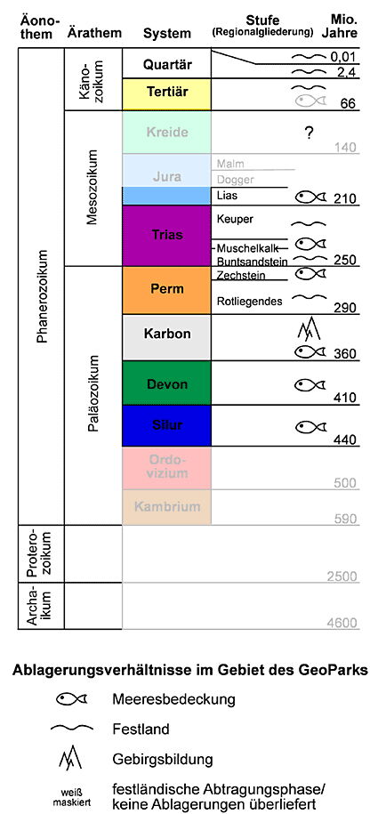
The oldest rocks of the Geopark are found in the southern Kellerwald and date back to the Silurian period. They contain fossils as witnesses of a time when life was still restricted to the oceans.
The geopark was also covered by a sea in the following geological eras Devonian and Carboniferous.
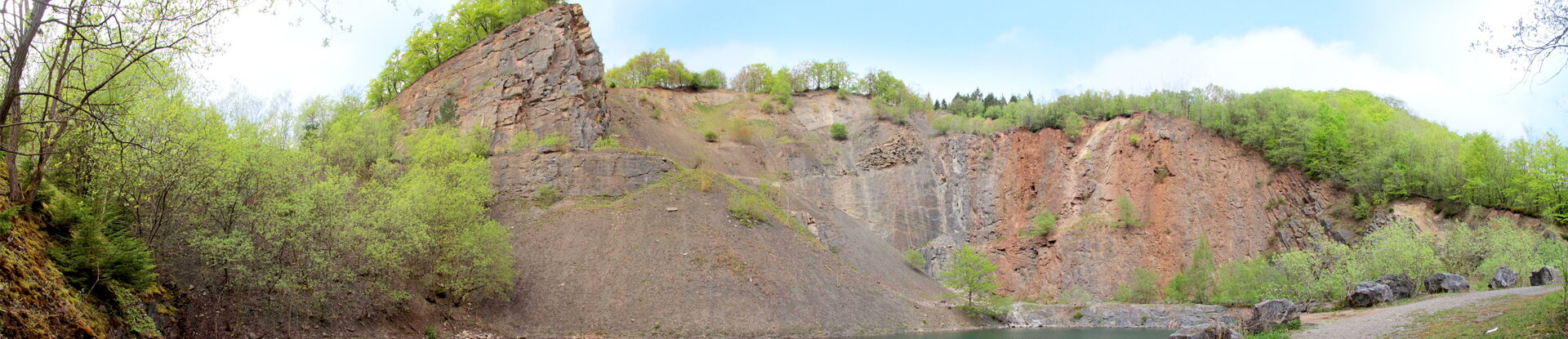
Devonian diabase and diabase tuffs (shellstones, main greenstone) are intercalated between these marine deposits in the (pre-) Upland (e.g. near Adorf) and in the southeastern Kellerwald (e.g. Bilstein cliffs near Bad Wildungen). They are volcanic igneous rocks that intruded at tectonic zones of weakness and fractures at the seafloor. Particularly large extent reaches in the Geopark the rocks of the Lower Carboniferous, which, as in most of the Rhenish Slate Mountains, are predominantly developed in a synorogenic, clastic facies, the Kulm. These are clay slates and graywackes, and alum and siliceous slates, siliceous limestones and lydites also occur.
Large-scale displacements of the Earth's crust finally led in the Upper Carboniferous to the collision of a mainland coming from the south (Gondwana) with a northern landmass (Laurasia, "Old Red Continent"). The constricting forces folded the originally horizontally deposited marine sediments into a mountain range ("Variscan mountain building") - the Rothaargebirge (Hochsauerland) and the Kellerwald were formed. In the following Upper Carboniferous and Lower Permian the mountain landscape was increasingly leveled by weathering and erosion. As an after-effect of the mountain building, large depressions and trench zones developed at weak points of the earth's crust, which absorbed the red-colored erosion debris of the Variscan mountains (Medebacher Rotliegend-Senke).
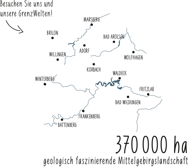
At the end of the Palaeozoic, in the Upper Permian, the Zechstein Sea penetrated valleys and depressions on the eastern edge of the ancient Variscan mountains. The Kellerwald horst remained as an island between two subsidence areas, the Korbach Bay in the north and the Frankenberg Bay in the south. Periodically, the Zechstein Sea was able to advance from the north to the mainland several times. In the meantime, in the dry-hot climate, the salty sea water evaporated again and again. As evaporation residues first lime and with further evaporation gypsum was precipitated. The Zechstein limestones still mark the former coastline on the eastern edge of the Rhenish Slate Mountains between Marsberg in the north and Wetter in the south of the Geopark. The Korbacher Spalte, world-famous site of fossil land vertebrates from the Permian period, is also laid out in Zechstein limestones.
At the beginning of the Mesozoic, the Geopark was located at the edge of a large-scale subsidence area (Germanic Basin). The resulting depositional space was an intermittently marine, but predominantly terrestrial inland basin, into which sediments were carried from the surrounding uplands. During the Buntsandstein this happened mainly by rivers, which brought in sandy-silty-clayey material from the south in cyclic alternation. The sandstone table of the Burgwald and extensive sandstone deposits in the northeast of the Geopark (Waldecker Tafel) are witnesses of these processes. In the highest Buntsandstein a sea advanced from the southeast into the Germanic Basin. This initiated the marine phase of the Muschelkalk. In a warm shallow sea, under semi-arid climatic conditions, fully marine to lagoonal, calcareous to marly rocks were formed. In the area of the Geopark these sediments are only found on a very small scale in the eastern part. Originally deposited as far up as the Rhenish Slate Mountains, they were largely eroded away again in later periods of the earth's history.
In the Keuper period, continental conditions prevailed again. But already in the Upper Keuper again a sea penetrated into the area of the Geopark, whereby the marine domination of the Jurassic system was initiated. Deposits of the Jurassic sea are found only on a small scale in the northeast of the Geopark near Volkmarsen. The marine cover probably lasted until the Cretaceous period. In the Geopark, however, deposits of this epoch are only present in the very north in the transition to the Münsterland Cretaceous ("Sindfeld" near Marsberg), otherwise the associated rocks have been removed again. This is because movements of the earth's crust from the Upper Jurassic onwards caused Central Europe to be broken up into individual fracture floes (Saxon tectonics) and the area of the Geopark was again uplifted. This initiated a phase of erosion to which many of the older rock layers fell victim. Only in the east of the Geopark did the tectonic events create elongated, narrow graben zones (e.g. Volkmarser Graben, Naumburger Graben), in which younger deposits of the Mesozoic (Muschelkalk, locally also Keuper and Jurassic) have survived to the present day.
In the Tertiary period, expansions within the earth's crust created further fracture zones where basaltic rock melts could rise to the earth's surface. Witnesses of the strong volcanism at that time are, besides the Vogelsberg (one of the largest coherent volcanic areas in Central Europe), also many smaller basalt deposits in the Lower Hessian depression (Wolfhager Land) in the east of the Geopark. The climate in the Tertiary was tropically warm and humid, the lush forests of this time are preserved in massive lignite deposits in the Borken area. The intermittent marine cover of the eastern areas of the Geopark is preserved in the Kassel marine sands (e.g. GeoStation at Großer Gudensberg near Zierenberg). The deposits of the Quaternary period originate from the cold and warm periods of the last about 1.7 million years. Widespread are valley floors filled with glacial gravels and sands (especially the Eder and Schwalmaue), loess or loess-loam blankets (especially in depressions such as the Lower Eder Valley) or flowing soils (especially on the valley slopes of the low mountain ranges). During the ice ages, the area of the Geopark always lay between the ice sheets of northern Europe and the Alps in the south. Here, a space free of ice but characterized by periglacial conditions (permafrost soil) was able to develop, giving rise to typical landscape forms and sediment types (solifluction debris). Even younger than the glacial deposits are the valley fillings from the geological present time, the Holocene. The soils themselves are also Holocene formations: they were formed by weathering processes that only got underway after the climate warmed at the end of the Ice Age.